


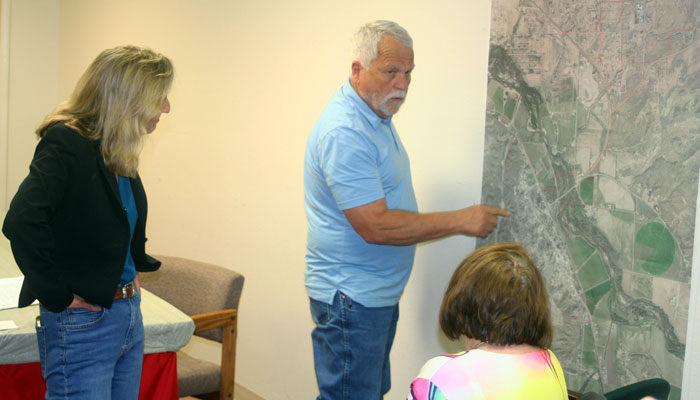
Walt Mares Photo/Gila Herald: Duncan Town Manager Terry Hinton points to an area on a map of the Duncan area where part of a levee was breached on the Gila River resulting in flood waters pouring into Duncan. In the foreground listening are U.S. Congressional candidate Kirsten Engle, left, and Arizona House of Representative candidate Sanda Clark. They met with Hinton in Duncan on Aug. 31.
Congressional, legislative hopefuls trying to find answers
By Walt Mares

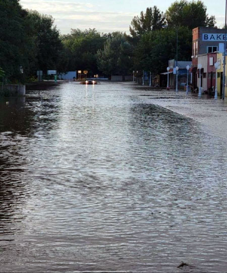
DUNCAN – It is a most legitimate question. Why is Duncan repeatedly flooded by the Gila River? Most of Duncan’s residents are asking that question about the recent flooding in this small southeastern Arizona town. They ask why local, state, and federal officials have not stepped in to protect Duncan from flooding as happened in late August.
Those questions were also posed to Duncan Town Manager Terry Hinton by Kirsten Engel and Sanda Clark on a visit to Duncan on Wednesday, Aug. 31. They also met with Greenlee County Supervisor Richard Lunt-Duncan, in Safford earlier in the day.
Engel is a Democratic candidate for the open U.S. Congressional seat in Congressional District 6. Clark is a Democratic candidate for Arizona State Representative in Legislative District 19.
Both candidates will have Greenlee County included in their districts should they be elected on Nov. 8.
Hinton said that Duncan is not being paid much attention to by the feds or the state of Arizona. For one thing, it is a small town with a population of about 800 folks.
As far as the Federal Emergency Management Agency, Duncan’s size pales in comparison with the many larger towns and cities across the U.S. that have recently been hit hard by flooding. All across the U.S., major flooding in California, Texas, Kentucky, and elsewhere has been FEMA’s focus.
Flooding nationwide has resulted in many deaths and total destruction of or heavy damage to homes and businesses. According to some news reports, floods have resulted in billions of dollars of destruction or significant damage.
That explains one reason for the lack of action by FEMA in Duncan.
So, Clark and Engel asked Hinton, why has there been a lack of action by Congress and/or the state of Arizona?
They pointed specifically to a study conducted by the Greenlee County All Hazard Mitigation Plan in 2016 and 2021 that expressed major concern about the ‘high likelihood’ of Duncan being flooded, with the potential for catastrophic consequences.
Engel and Clark said that the study done in 2016 had reportedly been received by Arizona Gov. Doug Ducey in 2017. He either has not read it or has ignored it, they said. Among other things, the study recommended meetings to address flood threats open to town residents, which have not been undertaken as far as Hinton knows. An updated study by the same agency in 2021 posed identical threat levels and recommendations.
Hinton, who has been town manager for only about four weeks, is well aware of the study.
He said that, however, “With the size of Duncan, 800, they’re not getting too excited about it.” He was referring to FEMA and the Arizona Department of Emergency Management (DEMA).
As far as the current possibility of more flooding in Duncan, Hinton said, “Right now we’re very vulnerable. If the river were to rise a foot or two, it would come into town.” He added it’s not a matter of “if” but “when.”
He said the town and the county have been working together well, but “neither the county nor town want to take responsibility for the levee.”
That brings up the question of when the levee was built. “Everybody is running sideways. Nobody knows when the levee was built,” Hinton said.

It may have been as far back as the 1930s, according to Congressional hopeful Engel, who as a former state legislator and lawyer has studied environmental issues in southern Arizona. She said that during the Dustbowl, the Soil Conservation Agency was formed as part of the Roosevelt administration’s New Deal to help farmers deal with catastrophic natural events. This may have included the designation of the National Resource Conservation Service founded by President Franklin D. Roosevelt during the Great Depression of the 1930s.
The service is now under the U.S. Department of Agriculture and continues to have some part in working with farmers to help protect their lands.

The 2016 study indicates that the Gila River flowing through Duncan was “highly likely” to cause a “catastrophic” flood in the near future. The study points to breaches of Duncan levees in the past years, resulting in significant flooding.
That is in contrast to the likelihood of catastrophic flooding in Clifton, 30 miles north of Duncan. The San Francisco River flows through the heart of Clifton and in the 2016 report, the likelihood there was listed only as “possible.”
Why the difference between threat levels for the only two incorporated towns in Greenlee County, both of which have rivers running through them?
According to the study, the only FEMA-certified levee within Greenlee County is the Clifton Levee. In contrast, Duncan has “non-levee embankments” which fail “on a regular basis”. It was reported that “this is especially true in the Duncan area where there have been documented flooding events involving breached or failed non-levee embankments.”

Prior to the current flood, the Duncan levees last gave way to major flooding in 2014, while in Clifton the last major, catastrophic flooding was on Oct 1-2, 1983. Many homes and businesses, particularly in South Clifton, North Clifton, and Eastside, were badly damaged or destroyed.
During the flooding, according to the U.S. Geological Survey, the San Francisco River flowed at 90,000 cubic feet per second through the narrow canyon of the affected areas of Clifton. The town now has a heavy-duty levee in place that protects South Clifton. It took 12 years for the project to be completed.
In areas of the flood plain where the levee does not exist, FEMA ordered the evacuation of homes in the flood plain, and homeowners were paid to relocate. Those homes were later demolished. That resulted in many people leaving Clifton to places such as the suburbs of Loma Linda and Verde Lee. Some moved to Safford, 45 miles distant, or far away as Tucson or Phoenix.
Legislative candidate Sanda Clark, whose family fled to the U.S. from Communist Romania when she was seven years old, opined that it shouldn’t matter that Duncan has fewer than 1,000 residents. “They are American citizens. They shouldn’t have to live in fear of a flood wiping them out in the next heavy rainfall. If the government can’t give them the protection of a certified levee, it should pay them adequately to relocate” out of the flood plain.