


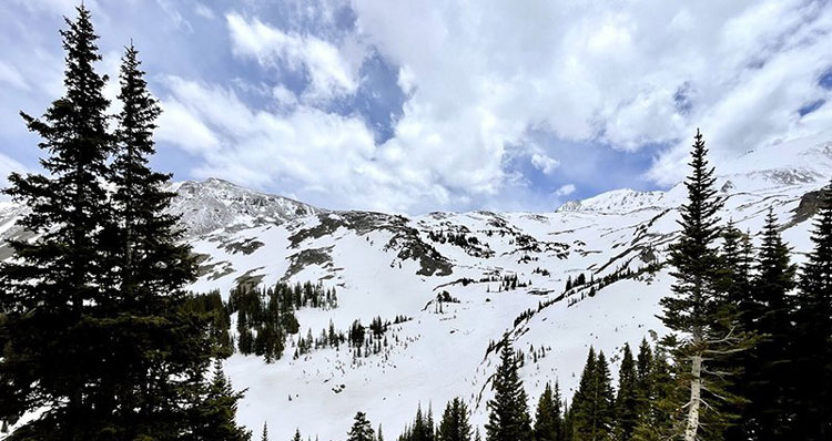
Photo By Alex Hager/KUNC: Snow hangs in west-central Colorado’s Elk Mountains in late May. The Colorado River gets the majority of its water from high-altitude snowpack, and climate scientists predict that less than normal will make it into streams and tributaries.
By Alex Hager/KUNC
During a parched summer in the arid Southwest, any rain can feel like a gift. But in reality, those precious summer showers barely move the needle when it comes to water.
“Regardless of what you get in the summer,” said Becky Bolinger, Colorado’s assistant state climatologist, “what really impacts the water availability in the Colorado River is what happens in the winter.”

As a drought-stricken region looks ahead to the summer, climate scientists are keeping an eye on high-mountain snowpack and its path to streams and rivers. Snow at high altitudes makes up the majority of the water in the Colorado River – where this past winter has left low totals. On top of that, warm weather and dry soil mean that snow is melting early and soaking into the ground before it can get to the river, which serves 40 million people from Colorado to California.
Snow in Colorado alone accounts for two-thirds of the water that flows into Lake Powell, one of the most important pieces of storage infrastructure on the overallocated river.
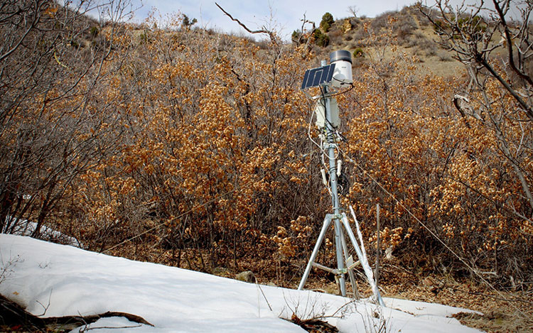
Many snow monitoring sites in Colorado measured peaks close to normal last winter, but a warm, windy and dry spring has driven the snowpack further below average for this time of year. Snow in the state’s high-altitude Western Slope is about 80% of average in most areas, but percentages in southern Colorado have dipped into the teens.
Even in places where snow totals are closer to normal, Bolinger said, not all runoff will make it into the rivers.
“Unfortunately, we’re dealing with dry soils from the previous start of the season, meaning that a lot of that is going to recharge the soils,” she said.
As consecutive dry years start to stack up, the ground becomes parched. When the snow melts on top, the soil acts like a sponge, soaking up water on its way downhill.
In addition, this year’s snow began melting early. Karl Wetlaufer, an assistant snow survey supervisor with the Natural Resources Conservation Service in Colorado, said that’s partially due to windy conditions, which blow dust on top of the snow, making a darker, more heat-absorbent surface.
“When that dust reaches the surface,” he said, “it retains a lot more of the energy from the sun. So we’ve also seen a dramatically accelerated snowmelt pattern and resulting streamflow runoff due to that dust on the snowpack.”
Rapid melt is especially evident in the San Juan Mountains of southwestern Colorado. At one measurement site, snow totals plummeted after peaking near average, melting more than three times more quickly than normal.
Between the dust, dry soil and higher-than-normal temperatures forecast for the West, mountain snow won’t be as helpful as the Colorado River needs it to be.
“It is going to be many, many years before I think we’re going to be able to get back up to any semblance of normalcy,” Wetlaufer said.

The region banks water in reservoirs from Wyoming to Arizona and those stores are getting reduced as homes and farms keep drawing water out. At this rate, the snowmelt just can’t keep up. Water levels in Lake Powell have dropped to the point of crisis. As state and federal agencies scramble to refill it with stored water from other parts of the basin, it looks unlikely that many of the region’s reservoirs will see any significant refill from snowmelt.
“I would definitely say that this year’s snowpack is not going to be enough to substantially increase those storage values,” Wetlaufer said.
Hundreds of miles downstream in Arizona, water experts also put a lot of stock in the snow. State climatologist Erinanne Saffel said mountain snow is still the difference-maker in replenishing groundwater, a method Arizona uses to store excess water underground to safeguard against a dry future.
Although snow does the heavy lifting in the Colorado River Basin, Saffel said summer precipitation makes a difference in more subtle ways.
“It recharges the stock ponds for the ranchers,” she said. “Those kinds of things are what we pay attention to. So when we don’t get that summer precipitation, there are implications.”
Close to the river’s headwaters near Grand Lake, Colorado, Bolinger said summer rains help reduce wildfire risk and keep soils saturated for the next snow season. Looking ahead, she said this summer’s forecast is still coming into focus.
“The big question will be, ‘Will the monsoon arrive and bring that needed moisture when we need it?’” Bolinger said. “After the memory of the snowpack is long gone and you need that summer moisture to carry you through to the fall. And that is a component that is really hard to predict.”
A seasonal temperature outlook from the National Weather Service shows that the areas containing pivotal snowpacks for the Colorado River are very likely to experience above-normal temperatures this summer. Meanwhile, summer precipitation in much of the Colorado River Basin is expected to be near normal.
A zoomed-out view of climate trends in the Colorado River Basin does not paint a hopeful picture for summers to come. Hot and dry years have been stacking up for more than two decades, and human-caused climate change is making it less and less likely that cool, wet seasons will come back in any significant capacity.


