
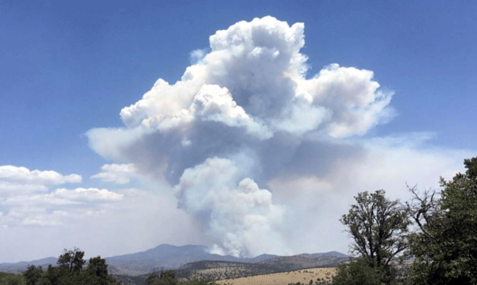
InciWeb Photo: Cloud coverage Monday night prevented mapping of the fire, but it appeared to have little growth since Monday.
Fire was at 14,625 acres with 5 percent containment as of Tuesday
Staff Reports
APACHE-SITGREAVES NATIONAL FOREST- Scattered dry thunderstorms moved over the fire yesterday, bringing a slight drop in temperatures and an increase in cloud cover. The increased humidity continued to moderate fire behavior, as minimal fire spread was observed. No significant activity was detected on the edge of the fire, but interior pockets of vegetation continue to burn.

The lightning-caused fire began June 6 roughly 22 miles north of Morenci and is being managed by a Southwest Area Type 2 Incident Management Team.
The increased cloud cover prevented the National Infrared Operations pilot from flying over the area to capture high-resolution images and fire detection data that informs acreage numbers. Since no data was collected, the reported acreage of the fire remained the same as Monday’s numbers. Based on predicted thunderstorm activity, firefighters do not expect to see any significant change in fire behavior today. However, an incoming drying trend is expected mid-week, bringing higher temperatures and lower humidity.
A helicopter repel crew was previously flown into the Blue River corridor to begin structure protection efforts and create defensible space around the cabins. Future protection measures may include using aluminum structure wrap to protect the buildings from radiant heat and embers if the fire were to move further in their direction.
The fire remains most active in the area around Red Mountain, burning through grasses and brush that make up the understory layer of timber forests. Firefighters are scouting for natural features such as ridgelines, trails, and areas with exposed rock and sparse vegetation that could serve as holding lines. As crews monitor fire activity along Highway 191 and the area around Rose Peak, helicopters may assist ground crews by dropping water buckets to cool the fire’s edge. Crews continue to make progress along the highway, extinguishing any fires that threaten to cross over to the western side.
Operations Section Chef Buck Wickham said he felt the firefighting operations were ahead of the fire and prepared to head it off and they are prepared to begin igniting more backburns if necessary.
“Our intention for the next couple of days is to monitor the fire behavior and ignition along the highway if need be,” Wickham said.
Firefighters have already burned about seven miles along U.S. Highway 191 to stop the fire’s spread.
“We want to keep the fire east of Highway 191,” Wickham said. “We also want to try to maintain a lot of the scenic values of Highway 191. And so, we’re burning out that highway and we’re also reducing the impacts of the fire close to the highway. Our prep work is pretty much done. We are prepped way north of the fire now.”
For the protection of the public and our firefighters, U.S. Highway 191 is closed in both directions between milepost 189 (just past Juan Miller Road) and milepost 225 (Blue Vista). This closure will remain in place through June 21 and may be extended as firefighters continue to secure the road corridor. Motorists should adjust travel plans accordingly. More information can be found at https://azdot.gov/adot-news/us-191-closed-eastern-arizona-mountains-due-bringham-fire.