

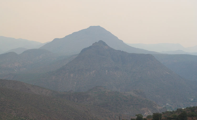
Walt Mares File Photo/Gila Herald: Clifton Peak, in the foreground, is obscured in a haze from smoke possibly contributed by three separate wildfires. Haze has obscured views in Graham and Greenlee counties as of late.
Contributed Article
| Salt Fire Location: 11 miles north of Globe, AZ near the junction of Hwy. 188 and SR 288 | Cause: Lightning Size: 20,228 acres | Percent containment: 0% Vegetation: Sonoran Desert Grass and Brush |
| Fire Strategy: Full Suppression | ||
| Gin Fire Location: 5 miles northeast of Globe, AZ in the Apache mountains west of Hwy. 60 | Cause: Lightning Size: 4,849 acres | Percent containment: 0% Vegetation: Grass and Brush |
| Fire Strategy: Full Suppression | ||
| Griffin Fire Location: 1.5 miles north of the Gin Fire | Cause: Lightning Size: 6,779 acres | Percent containment: 0% Vegetation: Grass and Brush |
| Fire Strategy: Full Suppression |
The Gila Department of Emergency Management issued a “Go” evacuation notification for Wheatfields Friday afternoon. The Red Cross Evacuation Center is open at the Lee Kornegay school in Miami. Last night’s infrared flight was able to provide more accurate acreage estimates.
Fire activity

Salt Fire: Yesterday firefighters completed a burnout operation along Forest Road 225 to keep the fire north of Gerald Wash. Sustained westerly winds pushed the fire toward Hwy. 188 in this area which prompted firefighters, assisted by an air tanker and helicopters to burn out along the highway to protect the Wheatfields community. A helicopter was also used to suppress an isolated pocket of fire near powerlines on the south end of the fire. Today, crews will hold existing lines and scout for areas to put in contingency fireline near communities. Firefighters will also work to minimize impacts to the values at risk in the area which includes the communities near Wheatfields and Roosevelt, Pinto Valley Mine, APS/SRP powerlines, and Hwy 188/288.
Gin Fire: The fire was most active on the north and east sides of the fire yesterday. Crews were able to burn along a section of Forest Road 220 to extend containment lines on the south flank of the fire. They also continued clearing along Forest Road 220 to the west with heavy equipment. The southeast flank of the fire saw little movement, so fire crews were able to prepare to burn out along Forest Road 224 if necessary. Today they will monitor and hold existing firelines on forest roads 220 and 224 and look for ways to minimize impacts to US 60 on the east flank of the fire.
Griffin Fire: The Griffin Fire crossed Highway 60 and has moved onto the San Carlos Apache Reservation. The highway remains closed in both directions from SR-73 (311) to S Vuksanovich Dr (254). Visit AZ511.gov for the latest information. Incident personnel will work to protect the Griffin and Tucker Ranches and identify opportunities to keep fire south of Forest Road 330 (Seven Mile Wash Rd.). The fire team is coordinating with fire managers from the San Carlos Apache Tribe to identify values at risk and potential holding features in the area.
Communities Affected: As a result of the fires, the Gila County Sheriff’s Office and Gila County Emergency Management have recommended the following areas be placed on “Go” Evacuation Status: Areas on both sides of State Route 188 from Bixby Road to the 188 / 288 Junction. Including all of Wheatfields.
The following communities remain on “Set” Evacuation Status: Roosevelt Estates, Roosevelt Resort, Rockhouse, Spring Creek, Hay Hook, and Quail Run. For more emergency alert and Red Cross evacuation information, visit http://www.readygila.com/.

Roosevelt Lake Recreation: Roosevelt Lake and adjacent recreation sites remain open to the public, with the exception of Bermuda Flat, Cholla Bay, and Bachelors Cove which are closed due to concerns for potential flooding after the Bush Fire earlier this summer.
Smoke: Smoke will lift and disperse to the southeast, with moderate smoke impacts to the communities of Miami and Globe. The heaviest impacts are expected over the San Carlos and Peridot communities as smoke from all three fires may combine in that area. Salt Wildfire Smoke Forecast can be found at: https://azdeq.gov/WildfireForecast?fire=saltfire
Weather: Winds are expected to be from the west from 5 to 13 mph in the afternoon with gusts to 30 mph. There is a possibility of strong outflow winds from thunderstorms in the evening. Higher humidity levels around 30 percent are anticipated today. Temperatures are predicted to reach 99 degrees with a 20 percent chance of rain. Firefighters will be dealing with erratic gusty winds as well as the potential for more lightning and downdraft winds from thunderstorms.
Values: Firefighter and public safety are the highest priorities on these fires. The fire area includes multiple communities, power lines, mines, range improvements, and historical sites, which firefighters are working hard to assess and protect.
Closures and Restrictions: ADOT has Hwy. 188 closed from SR 188 Old Alignment (MM232) to E Del Rio Ln (MM216). SR 288 is closed from the junction of Hwy. 188 to FR 465. Highway 60 is closed from SR-73 to S Vuksanovich Drive. For more updates on highway closures and restrictions visit https://www.az511.gov/.
The Tonto National Forest has issued a Public Safety Closure Order for the area impacted by these fires, for more information visit: https://www.fs.usda.gov/alerts/tonto/alerts-notices or https://inciweb.nwcg.gov/incident/closures/7019/