

Contributed Photo: A saguaro cactus is silhouetted by an orange glow from the fire.
Griffin Fire continues to progress into the Seven-mile Drainage
Contributed Article
| Salt Fire Location: 11 miles north of Globe, AZ near the junction of Hwy. 188 and SR 288 | Cause: Lightning Size: 20,809 acres | Percent containment: 57% Vegetation: Sonoran Desert Grass and Brush |
| Fire Strategy: Full Suppression | ||
| Griffin Fire Location: 5 miles northeast of Globe, AZ in the Apache mountains west of Hwy. 60 | Cause: Lightning Size: 33,403 acres | Percent containment: 30% Vegetation: Grass and Brush |
| Fire Strategy: Full Suppression |
Yesterday, ground crews assisted by air tankers and helicopters, responded to the lightning-caused Champion Fire 1.5 miles south of the Griffin Fire in Champion Creek, east of Highway 60. Fire managers expect the Griffin Fire to merge with the Champion Fire later today. Expect additional fire equipment and personnel to be driving through San Carlos and the Sevenmile communities as they fight these fires.
Overview
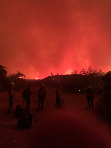
- The Griffin Fire continues to move in the direction of Upper Seven-mile.
- Firefighters continue to suppress the Salt and Griffin Fires. Total resources on the ground for both fires are 431 personnel.
- Thunderstorms passed over parts of both fires Sunday evening, bringing varying amounts of rain.
- Fire activity and movement will continue to be driven by dry fuels, terrain, slope, and potential of winds from thunderstorms through the area. We are expecting higher temperatures and lower humidity over the fire area for the next several days. The chance of afternoon thunderstorm buildup and outflow winds will remain a concern for firefighter safety.
- Highway 60 has reopened for travel in both directions with a pilot car through the fire area. Expect delays.
- Highways 188 and 288 have also reopened.
- New road closures are being implemented on the San Carlos Apache Reservation. Road 1300 (near Highway Tank) and road 900 are closed to all traffic at this time. Please be careful while driving in the fire area as firefighters are working along roadways.
Griffin Fire (merged with Gin Fire): - The Griffin Fire continues to move east and south on the San Carlos Apache Reservation. Parts of the fire received rain on Sunday night. The fire is burning in two primary locations and in two different vegetation types. The southeast flank of the fire is burning in light fuels (1 to 2’ grass) east from Sevenmile Mountains into Brushy Basin. Fire in this area is moving slowly under the influence of light westerly winds. The northern perimeter of the Griffin Fire is over 1000′ higher in elevation and burning through chaparral and brush with a grass understory. The northern portion of the Griffin Fire showed minimal movement yesterday, but pockets of heat were detected within Storm Canyon. Firefighters continue to protect the Griffin, Winters, Mcmillanville, Adobe, Haystack, and Tucker Ranches and keep the fire south of FR 303 (Sevenmile Wash Rd.). Firefighters are also taking fire suppression actions in the Sevenmile Mountains and Sevenmile drainage. Fire managers are working in close coordination with the San Carlos Apache Tribe to protect communities and limit the fire’s growth on the portion burning on the San Carlos Apache Nation.
Salt Fire:
Firefighters continue to patrol and monitor firelines on the north and east side of the fire. Recent rains decreased fire activity yesterday on the Southwest flank of the fire which allowed firefighters to construct fireline directly on the fire’s edge near Barnes Peak. Today crews will continue to build direct lines where possible and scout areas for contingency firelines to secure the southwest corner of the fire and prevent further spread to the south. Occasional smoke, flames and ash whirls from within the burned area may be visible from the highway and nearby communities.
Communities Affected:
The communities threatened by the Salt Fire were returned to “Ready” Evacuation Status this morning. They include Wheatfields, Roosevelt Estates, Roosevelt Resort, Rockhouse, Spring Creek, Hay Hook, and Quail Run. For emergency alert and Red Cross evacuation information, visit http://www.readygila.com/.
Roosevelt Lake Recreation:
Roosevelt Lake and adjacent recreation sites remain open to the public, with the exception of Bermuda Flat, Cholla Bay, and Bachelor’s Cove which are closed due to concerns for potential flooding after the Bush Fire earlier this summer.
Griffin and Salt fires Smoke Report:
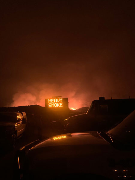
Overnight smoke will move into the drainages and low lying areas adjacent to the fire. A northeasterly flow is expected to enhance the diurnal wind pattern, allowing smoke from a wildfire located north of the Griffin to combine with the Griffin and Salt fires’ smoke. This could cause heavier smoke impacts throughout the night into the early morning hours in the areas of San Carlos, Wheatfield, and Roosevelt. The heaviest of impacts are expected between 4 a.m. and 9 a.m., with the smoke lifting out by 10 a.m. https://azdeq.gov/WildfireForecast?fire=griffinfire
Closures and Restrictions: The Tonto National Forest has issued a Public Safety Closure Order for the area impacted by these fires, for more information visit: https://www.fs.usda.gov/alerts/tonto/alerts-notices or https://inciweb.nwcg.gov/incident/closures/7019/
Values: Firefighter and public safety are the highest priorities on these fires. The fire area includes multiple communities, power lines, mines, range improvements, historical sites, and natural resources, which firefighters are working hard to assess and protect.