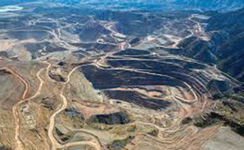


Walt Mares File Photo/Gila Herald: In this 2020 file photo, the view from Morenci shows thick, heavy smoke that blankets mountain peaks near Clifton. The smoke from the California wildfires was so thick and heavy it caused respiratory problems for many people in Morenci and Clifton, which is located about 400 feet below Morenci. Prescribed burns currently underway in the Clifton Ranger District, in which both communities are located, should hardly be detectable, depending on which way the wind blows, if any wind blows at all.
Travelers on Coronado Trail may see delays
By Walt Mares
In the event smoke from forest fires begins blowing again into Greenlee County? Not to worry.
The smoke will not be blowing in from raging wildfires in California or elsewhere in the far western U.S. Much unlike those monstrous fires smoke in Greenlee should not be anywhere heavy enough to choke a horse or a human for that matter.
The smoke we may be seeing quite soon will probably be coming from prescribed burns in the Clifton Ranger District and Alpine District in the Apache-Sitgreaves National Forest.
The burns will be conducted Nov. 8-20. The Forest Service does caution that the burns may affect highway traffic and travel plans.

It advises that in the Clifton District U.S. 191 – the Coronado Trail – will be affected with equipment and smoke resulting in possible travel delays.
The Apache Forest covers about two-thirds of Greenlee County. Additional forests in the region are the Sitgreaves, thus the Apache-Sitgreaves National Forest.
Where the smoke blows may depend on what direction winds blow if there are any winds.
With the annual cavalcade of colors coming with tree leaves turning bright, red, gold and orange there will very likely be several folks who want to see the colors of the fall season. Thus, motorists should be aware of prescribed burn activity in the higher country.
Burns will take place in the Clifton District from East Eagle Mud Springs Rx Project Phase 1 Block D./ ON U.S. 191 from Blue Vista Lookout to Stray Horse Campground, East from Salt House Creek to Trail#18.
In the Alpine District, burns will take place from Wallow West Unit Four Rx Project, the location is FR 25 South to the Black River and West of FR25 to FR 25G on the East.
Smoke will be a consideration in the vicinity of the prescribed burns depending on the weather and caution should be used when traveling in the area.
Travelers may obtain up to date on news from the A bar S at the Forest Service website https://www.fs.usda.gov/asnf, on Twitter @A_SNFs, and on facebook.com/apachesitgreavesnfs.
Prescribed burns may be extremely helpful in eliminating underbrush and other small growth vegetation that can greatly contribute to the beginning of large wildfires.
Much of the western U.S. has suffered wildfires that have not only destroyed large parts of many forests but have also taken a massive human toll on homes and, foremost, resulted in many deaths.