
Southwest Incident Management Team 4 has taken command of the Bronco Fire
Staff Reports
BYLAS – The Albuquerque Zone Type 3 Incident Management Team assumed command of the Goodwin Fire at 6 a.m. today, southwest of Bylas, Arizona, as firefighting efforts intensify across the region. Simultaneously, the Southwest Incident Management Team 4 took over the Bronco Fire, located 30 miles northeast of San Carlos, as both lightning-caused wildfires continue to burn through challenging terrain and hot, dry conditions.
Goodwin Fire update
The Goodwin Fire, sparked by lightning on Aug. 6, has consumed 1,005 acres southwest of Bylas, near White Springs and southeast of Mt. Turnbull. With 0% containment and 100 personnel deployed, the fire is burning through short grass, brush, and juniper, exhibiting active behavior due to persistent hot and dry conditions. Temperatures today were expected to exceed 100 degrees, with a slight chance of showers and thunderstorms in the late morning and early afternoon.
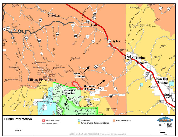
Firefighters are focusing efforts on the southeast corner, prioritizing structure protection and scouting for potential control lines. Limited resources, strained by multiple active fires in the region, have prompted the transition of personnel from the Bronco Fire to bolster operations. A Temporary Flight Restriction (TFR) is in place over the fire area, and the public is urged to avoid the region and refrain from flying drones, which could disrupt air operations. Smoke visibility is increasing, and those sensitive to smoke are advised to visit fire.airnow.gov for health precautions.
Bronco Fire update
The Bronco Fire, reported on Aug. 3, has grown to 15,836 acres with 0% containment and 145 personnel assigned. Burning through brush, juniper, ponderosa, grass, and chaparral, the fire has displayed extreme behavior, including crowning, wind-driven runs, and long-range spotting. Located 30 miles northeast of San Carlos, near Phillips Park Tank and the Hilltop Unit, the fire reached Forest Road 1426, prompting crews to prepare Forest Road 1429 as a contingency line using dozers and masticators. Firefighters are also securing Forest Roads 1400 and 1100, supported by a Type 1 helicopter conducting water bucket drops when visibility allows.

Hot, dry, and windy conditions yesterday fueled rapid fire growth, but a subtle increase in moisture is expected today, bringing more afternoon clouds and high-based showers. Temperatures will remain in the mid-to-upper 90s. The San Carlos Apache Tribe Reservation is under Stage 3 fire restrictions, prohibiting campfires and closing higher elevations, including Point of Pines, Hilltop, Route 8, and Seneca areas. The public is urged to avoid the fire area and refrain from drone use to ensure firefighter safety. For smoke-related health concerns, visit fire.airnow.gov. Contact the San Carlos Apache Tribe Forestry Department at (928) 475-2326 ext. 352 or 321 for further information.
Safety and community impact
The health and safety of firefighters and the public remain the top priority for both incidents. Authorities emphasize the danger of unmanned aircraft systems (UAS), reminding the public, “If you fly, we can’t!” as drones can ground critical air operations. Smoke from both fires is increasingly visible, impacting air quality and posing risks to sensitive groups.
For the Bronco Fire, public information is available at 2025.bronco@firenet.gov or (928) 218-4240 (8 a.m.–8 p.m.), with media inquiries directed to (602) 463-8530 (8 a.m.–8 p.m.). Additional details can be found at inciweb.wildfire.gov/azsca-bronco-fire.
As firefighting teams work tirelessly to contain these wildfires, officials urge the public to stay informed, adhere to restrictions, and prioritize safety in the affected areas.