Favorable weather conditions in place for hazardous fuels reduction work
Contributed Article/Courtesy Forest Service
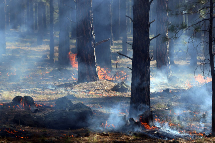
SPRINGERVILLE — The Apache-Sitgreaves National Forests are planning prescribed fire operations beginning the week of March 23, pending all required approvals. We estimate this work to be completed by April 17. We use prescribed fires to help reduce overgrown vegetation and protect local communities, infrastructure, and natural resources from wildfires.
Black Mesa Ranger District planned prescribed fire operations may include:
- Heber Brush Pit, Hwy 277 and FR 488G. The section of the brush pit scheduled for burning will be temporarily closed to the public. This closure applies only to the area being treated; the remaining portion of the brush pit will stay open unless conditions change (map attached).
- Hidden 2 Rx, 348 acres, 2 miles west of Forest Lakes on the north side of Hwy 260 (map attached).
- Sinkhole Rx, 876 acres, approximately 4 miles west of Forest Lakes. The Sinkhole prescribed burn will include lands in and around Willow Springs Lake (map attached). For public safety purposes, access to the lake will be closed from the time ignitions take place and up to 72 hours after, or until fire management declares the area safe. The temporary closures will affect the primary lake access route (FSR 149), Sardine Point, The Fisherman, FSR 235, and the Willow Springs Bike Loop. Fire personnel will continually evaluate conditions and will reopen these areas as soon as they are determined to be safe for public use. Our Apache-Sitgreaves National Forests Facebook page will be updated regarding the status of the temporary closures.

Those areas may be closed to the public for several days for public safety. Watch for warning signs along roads near all prescribed fire areas before and during burns.
Smoke and fire may be visible from Hwy 260 and the Forest Lakes community. For more detailed information about air quality, go to AirNow online or download the app. When driving, slow down and turn on your headlights when you encounter smoke on the road.
We will evaluate weather conditions in the hours before a burn begins. If conditions warrant, scheduled prescribed fire activities may be canceled.
Stay informed about the scheduled prescribed fires through the forest website, social media channels, and InciWeb, the interagency incident information system. We will notify county emergency management officials when burning begins.
About the Forest Service: The USDA Forest Service has, for more than 100 years, brought people and communities together to answer the call of conservation. Grounded in world-class science and technology– and rooted in communities–the Forest Service connects people to nature and to each other. The Forest Service cares for shared natural resources in ways that promote lasting economic, ecological, and social vitality. The agency manages 193 million acres of public land, provides assistance to state and private landowners, and maintains the largest wildland fire and forestry research organizations in the world. The Forest Service also has either a direct or indirect role in stewardship of about 900 million forested acres within the U.S., of which over 130 million acres are urban forests where most Americans live.