

Goodwin Fire shows minimal growth – 20 percent containment
Staff Reports
SAN CARLOS APACHE RESERVATION – Three lightning-caused wildfires—the Goodwin, Bronco, and Indian Creek fires—are burning across the San Carlos and Fort Apache Apache Reservations in Arizona, with crews working diligently to contain their spread amid challenging conditions. Despite extreme drought and dry fuels, recent weather patterns and strategic firefighting efforts have led to progress, particularly for the Goodwin Fire, which has shown minimal growth.
Goodwin Fire: Minimal growth, 20% containment
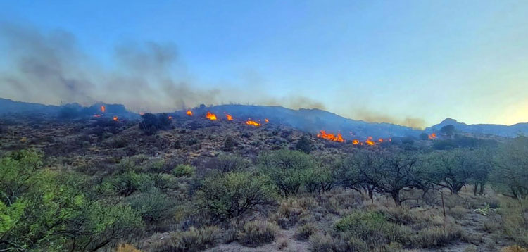
The Goodwin Fire, located 12 miles southwest of Bylas, has burned 1,010 acres since it was sparked by lightning on Aug. 6, 2025. As of Aug. 12, the fire is 20% contained, with 145 personnel working to secure its perimeter. Fueled by short grass, brush, and juniper, the fire has exhibited only creeping and smoldering behavior, holding within existing lines despite hot, dry, and windy conditions.
Firefighters have focused efforts along Tribal Road 64, extinguishing hot spots and strengthening containment lines along the southeast flank while moving west. Crews are scouting rugged terrain to identify potential control lines and improve road systems for containment. Aerial reconnaissance conducted on Aug. 11 showed minimal heat, and a Type 1 helicopter remains on standby to cool any remaining hot spots. With dry lightning in the forecast, resources are prepared to respond to potential new fire starts.
Weather conditions remain challenging, with temperatures above average, humidity as low as 15–20%, and northwest winds gusting up to 15–20 mph expected in the afternoon. A Temporary Flight Restriction (TFR) is in place over the fire area, and the public is urged to avoid flying drones, which could disrupt aerial operations. Smoke from the fire may be visible, and sensitive groups are advised to visit fire.airnow.gov for air quality information.

Bronco and Indian Creek Fires: Persistent Challenges
Further north, the Bronco Fire, located 30 miles northeast of San Carlos, has consumed 18,131 acres since igniting on Aug. 3. The Indian Creek Fire, 10 miles southwest of Whiteriver, has burned 2,513 acres since starting on Aug. 5. Both fires, fueled by grass, brush, and timber, remain at 0% containment, with a combined 690 personnel assigned.
The Southwest Area Incident Management Team 4 (SW Team 4) assumed command of the Bronco Fire on Aug. 10 and is employing a full-suppression strategy for both fires, prioritizing firefighter and public safety. Unexpected rainfall on Aug. 11 tempered fire behavior, aiding suppression efforts. On the Indian Creek Fire, crews supported by helicopter bucket drops have held the fire south of Y2 Road and are building firelines along Y4 Road, where sparser fuels may slow growth. Bulldozers are preparing contingency lines northwest of the fire.
For the Bronco Fire, firefighters are focusing on securing the south and southwest perimeters along Roads 1400 and 1100, using these as containment features. Handcrews, engines, and bulldozers are strengthening firelines to prevent northward spread, with northwest winds testing containment efforts.
A community meeting was held on Aug. 10 at the Assembly of God Church in Cedar Creek to update residents on the Indian Creek Fire. The meeting was recorded and posted on the BIA Forestry & Wildland Fire Management – Fort Apache Agency’s Facebook page.
Weather and smoke outlook
While early cloud cover and unexpected rainfall provided some relief on Aug. 11, the forecast for Aug. 12 includes a 20% chance of afternoon showers and thunderstorms, with minimal wetting rains expected. Higher humidity and a greater chance of rain are forecast later in the week. Smoke from the Bronco and Indian Creek fires continues to impact White Mountain communities, and residents are encouraged to take precautions and monitor air quality at wildlandfiresmoke.net.

Closures and safety
Extensive closures are in effect on the Fort Apache Reservation, spanning from Amos Wash to Black River, east to the Bonito Creek and Black River confluence, and north to Seven Mile. The San Carlos Apache Reservation remains under Stage 3 fire restrictions, prohibiting campfires and closing higher-elevation areas like Point of Pines, Hilltop, Route 8, and Seneca to the public. For more information, contact 928-475-2326 ext. 352 or 321.
The public is urged to avoid the fire areas and respect the TFR over the Goodwin Fire to ensure the safety of firefighting operations. Drones in the area could ground critical aerial resources, delaying suppression efforts.
Ongoing efforts
With 469 total personnel across the three fires, firefighting teams are capitalizing on favorable weather to strengthen containment lines and prepare for potential new lightning-caused fires. The combination of rugged terrain, extreme drought, and unpredictable weather continues to challenge crews, but their coordinated efforts are making headway in protecting communities and natural resources on the San Carlos and Fort Apache Reservations.